")
")


{gallery count=1 alignment=right}galleries/hiking/banovina/petrinjska_setnica/DSC03751.JPG{/gallery}
Destination: "Petrinjska šetnica" - circular marked trail across the hills above Petrinja
Beginning and the End: The bridge over the Petrinjčica (Matija Gubec street)
Duration: about 1.5 - 2 hours of walking (about 6 km)
Difficulty: Easy signed trail
Altitude difference: 100 m
{gallery}galleries/hiking/banovina/petrinjska_setnica{/gallery}
Route description
- The Petrinja promenade starts at the new bridge on the Petrinjčica. It goes upstream along the left coast to the bridge near the hospital and an asphalt road climbs along Ćiro's hill in the direction of "Villa GAVRILOVIĆ". Off this road to the right there is a branch that leads to the cemetery of St. Rok (Grobljanski path). After a hundred meters left there is a separate forest trail, which comes out onto the clearing near the monument to the memory of the executed defenders of Petrinja. From the monument continues the macadam road at the crossroads near St. Elijah's church. Here we turn to the right on the road that leads us towards the facilities of water supply of Petrinja. About 150 meters from the crossroads, there is a trail right downhill through the meadow that goes to the forest. The trail leads into the Popova forest to the spring "Jelen" (a deer in English). Our promenade continues to the crossroads in front of the water supply. To the right there is the 6th August Street, leading towards the city. We continue straight along a macadam road in the direction of the cemetery of St. Trinity. We pass the cemetery and we descend towards the Resort PIGIK. From the crossroads at PIGIK we descend through the Vinogradska Street to the Matthias Gubec Street and we follow it to the new bridge on the Petrinjčica.
Signs
- The primary signs of the Petrinja Promenade are around red and yellow marks. These marks are used on the European hiking trails, We wanted to distinguish The Petrinja Promenade from the mountain trails.
Đuro Priljeva,
Petrinja, 3rd October 1999
This extract is taken from a document written by Đuro Priljeva. The complete document (in Croatian)is here.
Maps and GPS data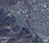
- Topographic map 1:25 000 Sisak-Zapad (old tag TK25 371-2-1), Državna geodetska uprava, Zagreb, 2006.
- Map of Petrinjska Šetnica (by Dražen) with drawn GPS data is here
- KML file for viewing Šetnica in GoogleMaps
Appropriate season for visiting: whole year
Equipment: Standard equipment for walking. There are no springs (except Jelen) along the route, but the trail passes through a populated area
Related trips:
Access and accommodation: See Petrinja and Hrastovica hill - Approach and Accommodation
Additional information
- Information about The Petrinja Promenade can be found on pages of the Tourist Board of Petrinja.