")
")


Gorski Kotar

Destination: Samarske Stijene - western group and Zub (about 1280 m)
Starting and ending point: Crossing at 13th km of the road Mrkopalj - Jasenak (or Ratkovo Shelter) - (1100 m a.s)
Length: 5,5 h / 6,5 km Ascents: 600 m; Highest point: 1302 m;
Difficult level: Fit: 🥾🥾⚪⚪ (moderate) Technical: difficult/very difficult
Tagline(s): A rounded challenging route (with some optional easy climbing details) through the labyrinth of the Samarske Stijene with optional ascent to the peak called Zub (Tooth). The route covers a few summits of Samarske Stijene (The Summit of Samarske Stijene, Piramida, Stepenica..).
Read more: Samarske Stijene (Saddle Rocks) - western group and Zub (the Tooth) - guide

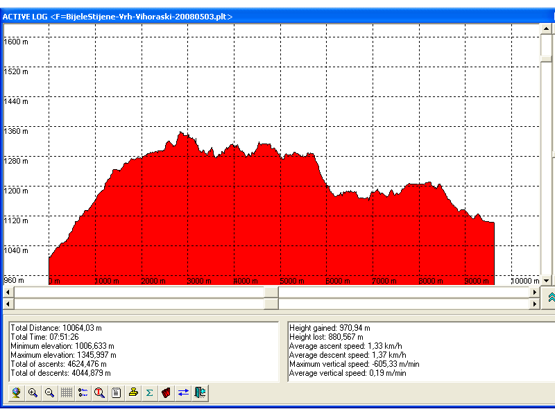
Destination: Bijele Stijene - Summit (1334 m) - Vihor Trail
Beginning: Parking at the branch of the road Mrkopalj-Jasenak
End: the crossing "13th km" on the road Mrkopalj-Jasenak
Duration: about 6 h
The level of difficulties: Moderate to high
Altitude difference: 325 m Altitude profile is here
Attractivity: *** (of ***)
Convenient season for visit: Summer
Introduction:
- Bijele stijene (White Rocks) is a 4 km - long chain of rocks of unique beauty, cut with wood and little green dales. Very suitable place for a runaway from noise, pollution and other side-effects of civilisation and summer heat.
- Bijele Stijene and Samarske Sijene (Saddle Rocks) are protected as a strict nature reserve. The Vihor's trail is one of the most beautiful hiking trails in Croatia. There is no more to say.. it is worth seeing.
Read more: Bijele Stijene (White Rocks), the Summit, Vihor Trail - guide
- You are here:
-
Home

-
Hiking
-
Hiking guide - YAMG
- Gorski Kotar
Who's Online
We have 568 guests and no members online