")
")


Europe

Destinations: Svartåmynningen naturreservat, Berg Locks, Vreta Kloster
Starting and ending point: Linköping
Trip duration: 3 h Length: 30 km
Trail type: Bicycliistic trail
Difficulty: Easy
Tagline: Nice, easy, bicyclistic trip from Linköping taht includes Svartåmynningen naturreservat, Berg Locks at Göta canal and historyc church (from 12th century) Vreta Kloster
Read more: Svartåmynningen naturreservat, Berg, Vreta Kloster, 2018-10-20

Destination: Tinnerö eklandskap
Starting and ending point: Smedstat Dammar (parking)
Length: 17,5 km Time needed: 5 h
Altitude difference: 25 m
Trail type: Easy walking
Tagline: Very nice walking through oak woodland, meadows and around the Lake Rosenkällasjön. A lot of wildness just a few km from the center of Linköping. My route was 17,5 km long, but it can be shortened or prolonged or combined with a bike. The trails through forests and the trail the closest to the lake are accessible by foot, only. The rest is accessible by bike (or by horse riding).
Read more: Tinnerö eklandskap, Naturreservat, Sweden, 2018-10-06
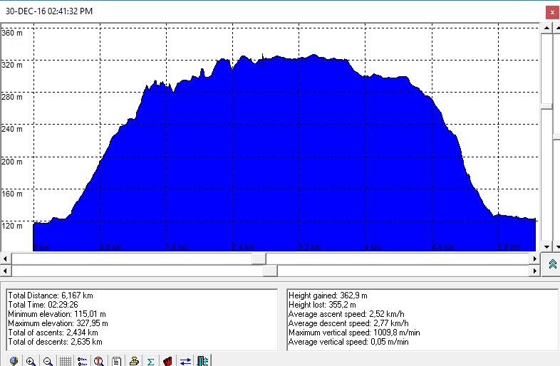
Neumannmühle - Bärenfangwände - Richterschlüchte - Krinitzgrab - Richtergrotte - Zeughaus, 2018-04-2

Destination: Bärenfangwände, Krinitzgrab, Richtergrotte
Starting and ending point: Neumannmühle (near Bad Schandau)
Time needed: 5 h
Difficulty: easy, some parts of the trail are steep
Altitude difference: 300m (see the altitude profile)
Description: A nice, easy walking through Saxony Switzerland National Park (Saxony, Germany).

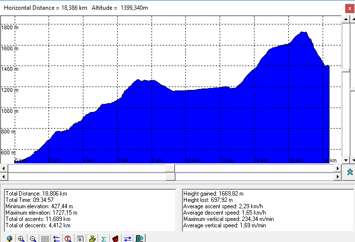
Destinations: Bärenschützklamm, Teichalm i Hochlantsch (1720 m)
Starting and ending point: Mixnitz (about 45 min of driving fromv Graz)
Time needed: 9 h
Altitude difference: 1300 m (see altitude profile)
Difficulty: Easy
Tagline: 16th sequential "Velebit", this time - "Stiermarkisch". We have visited very interesting, good arranged canyon (115 bridges, 9 scales, 2900 stairs..), a mountain lake, peak above 17090 m, and we have watched quarter finals of Match Russia-Croatia on brought equipment (by Vjeko). A lot of nice happening and landscapes.
Read more: Velebit 2018: Bärenschützklamm - Teichalm - Hochlantsch, Austria, 2018-07-07

Destination: Bastei (305 m)
Route: Kurort Rathen - Bastei - Stadt Wehlen
Starting point: Kurort Rathen
Ending point: Stadt Wehlen
Time needed: 2 h
Difficulty: easy (altitude profile is here)
Description: A short nice walking with visiting the famous Bastei bridge and some interesting cliffs in Saxony Switzerland (Saxony, Germany)
- You are here:
-
Home

-
Hiking
-
Hiking Trips
- Europe
Who's Online
We have 1258 guests and no members online