")
")


Mt Velebit - trips

Destination: Krupa, Krnjeza, Tulove Grede
Starting points: Golubić, Majstorska Cesta (Master's Road - Sveti Rok - Obrovac)
Difficulty: From easy signed trail to technically medium difficult details (ferrata in Krupa canyon, some climbing skills required in Tulove Grede and Krnjeza Canyon)
Tagline: 18th "Velebit" in a row. These time we did it all, we were at the both rivers sources, all group passed ferrata and the most are climbed Tulove Grede peak. The especially interesting was Krnjeza canyon, the river with a lot of contrasts: its canyon is deep as half of its length, the shortest in HR (700 m), deep source (the 106 m deep lake, deep canyon (300 m) and goat's trail with real goat at the most difficult part of the trail.
Read more: Velebit-2019, Krupa and Krnjeza, Tulove Grede, 2019-07-05

Destination: Sveto Brdo (1751 m)
Distance and duration (one direction): 4,5 h, 11 km Trail type: Signed hiking trail
Starting and ending point: the branch about 600 m before Mali Halan pass from mainland side at the road Sveti Rok - Alan - Obrovac
Difficulty: Difficult (due winter conditions and heavy backpacks)
Tagline: Nice trip with nice weather even without planned winter hiking training.
Read more: Dušice - Sveto brdo, Southern Velebit, 2019-03-09

Destination: Badanj, Krupa
Starting point: Planinarski dom Prpa (935 m)
Difficulty: Easy signed trail
Description: 15th Velebit in a row... despite the storm, the strongest bora in the last 12 years, we dared to experience that on Basača and visit Badanj, even in the rain, what was enough to get wet to the pants and stiff from the cold. Luckily, we have warmed up by the fire and the central heating. Tomorrow we visited Krupa downstream from Kuda's bridge and even swam in it.

Destination: Mt. lodge Zavižan (1594 m)
Duration/Length (in one direction): 6 h, 16 km
Difficulty: Difficult (because of winter conditions)
Starting and Ending point: Mt. hut Alan (1340 m)
Tagline: The trip is junction of cancelled HPD Zrin's Winter trip to Zavižan with traditional Silvester's ascent to Zavižan that is organized by HPD Sisak. Despite of official 3 cm of snow only, the major part of the part was covered by snow and ice and together with nice weather the very nice winter trip was happened.
Read more: Premužić Mountaineering Trail in Winter, from Alan to Zavižan (and return), 2018-12-29

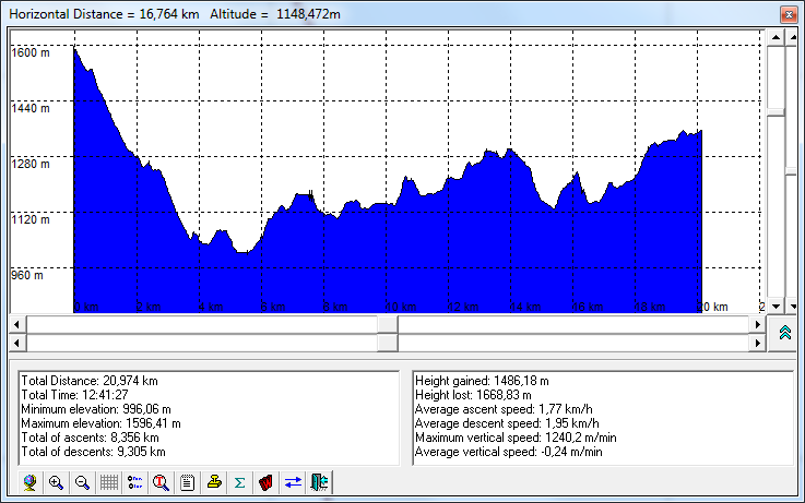
Route: Mt. Lodge Zavižan - Ciganište - Mt Hut Alan - Premužić Mountain Trail - Mt. Lodge Zavižan
Starting and destination point: Mt. Lodge Zavižan (1594 m)
Duration: two days ( 9 + 7 hours of walking)
Difficulty: Medium difficult marked trail (see the notes and altitude profile)
Tagline: The HPD Zrin Summer Camp 2015 main trip. Very nice trip despite of the giving up of a few hikers including the guide, extreme hotness for this region and a demanding trail. Probably the best moment of the trip was the welcome in the form of the cold beer, brought by our colleagues at the end of the route, after 12 hours of walking
Read more: Seaside Terrace - Premužić Trail, The North Velebit, 2015-07-23
- You are here:
-
Home

-
Hiking
-
Hiking Trips
- Mt Velebit - trips
Who's Online
We have 216 guests and no members online