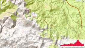
Destination: Sveto Brdo (1751 m)
Distance and duration (one direction): 4,5 h, 11 km Trail type: Signed hiking trail
Starting and ending point: the branch about 600 m before Mali Halan pass from mainland side at the road Sveti Rok - Alan - Obrovac
Difficulty: Difficult (due winter conditions and heavy backpacks)
Tagline: Nice trip with nice weather even without planned winter hiking training.
Route:
- Majstorska Cesta (Master's Road); the branch about 600 m before the pass from mainland side - Mt. Shelter Dušice - Sveto Brdo - Dušice
- Mt Shelter Dušice - Majstorska cesta
Notes from the trip:
It was the official trip of PD-a Runolist khiking club guided by Krešo (big thanks to him). The guest at this trip havr come from HPU Alfa & Omega, PD Bundek and HPD Zrin hiking clubs.
The start was planned from the monument at the beginning of the Majstorska Cesta due to expected snow on the road. In the motel Sveti Rok we have got the information that road is passable and the plan is changed to go by car as much as possible.
At Sveto Brdu, we were enjoying stunning view and we have found the broken cross built by German Army pioneers in 1996. It could not resist to torture of snow, winds, ice and thunders. We are looking forward for the reconstruction of this symbol of Sveto Brdo.
After returning to the shelter, we went to get water to 10 min of walking far natural spring. It was followed by dinner and socializing evening.
Photo-album:
The members of the group: Ivana, Aleks, Zoki, Danijel, Mario, Peđa, Saša, Dražen - 11 souls including guides
Maps:
- Južni Velebit (Southern Velebit), Map No 18a, M 1:30.000, SMAND d.o.o., Varaždin
- Topographic map No 18, NP Paklenica, HGSS
- OpenTopo map of the are is here.
Red tape: Possibility for mine-fields aside from the trail! It is dangerous not following the trail. The map of mine fields and mine suspicous areas are here.


