")
")


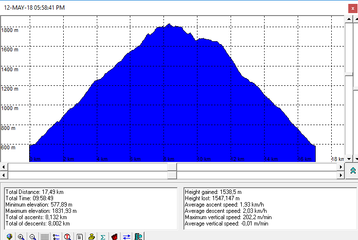
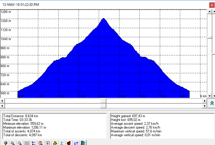
Destinations: Dinara (1830 m), Kijevski Bat (1206 m)
Ascent duration: Dinara 4 h, Kijevski Bat : 2 h
Altitude difference: Dinara about 1300 m (altitude ptofile), Kijevski Bat 650 m (altitude profile)
Difficulty:
- Dinara: Demaning (due to the distance and altitude difference) signed trail,
- Kijevski Bat: Medium
Opis: The trip at the day of opening Mountain Shelter Drago Grubać at Ošjak area (Mt Dinara). Nextt day, a little easier hiking to the Kijevski Bat (Mt Kozjak).

Route:
- Glavaš - Martinova Košara (pl. sklonište) - Dinara (Sinjal, 1830 m) - Ošjak (Pl. sklonište Drago Grubač, 1645 m) - Glavaš
Note: The trail via Ošjak is steeper and probably more convenient for ascent.
- Kijevo (Deer Farm) - Kijevski Bat - Kijevo
Photoalbums:

Dinara (Sinjal) by Dražen
Vrelo Cetine i Crkva Sv. Spasa by Dražen
Kijevski Bat by Dražen

Maps and GPS data:
- Dinara, Hiking-turistic map, Map No 40, M 1:30.000, SMAND d.o.o.
- In order to view GPS tracks from the trips in GoogleMaps application, please, click on the map icons:
Warning:
- The trail is close to the country border
- The part of the trail from Mt. Shelter Drago Grubać at Ošjak dto the connection to the trail Martinova Košara - Dinara is not signed (status: May 2018.)

