")
")


Destinations:
- Hom (Hum) - hiking
- Sozanj - hiking
- Lastovo (city) and Lučica - by foot and by bike
- Zaklopatica and Korita Bays - by foot
- Skrivena Luka (Hiden Port) - by bike
- Rača Cave - by bike and by foot
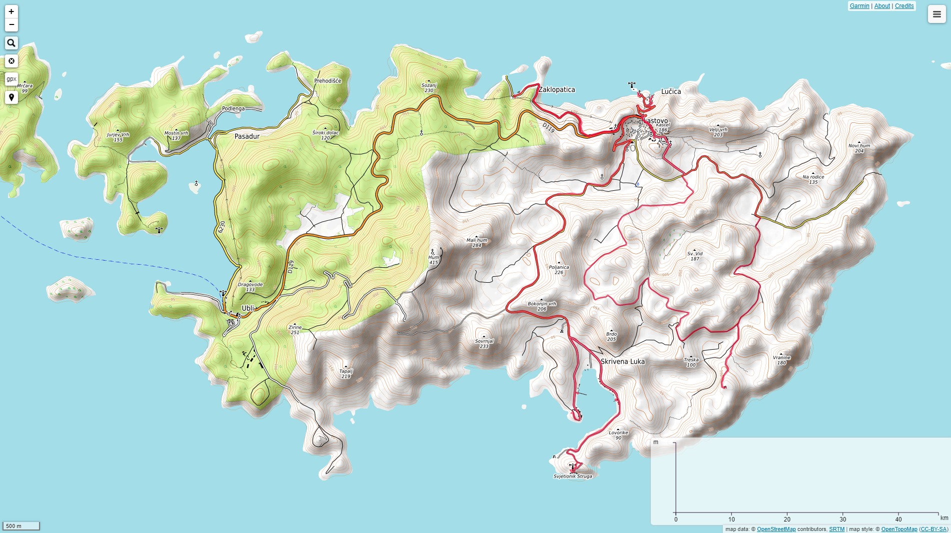
Tagline: A few impressions from visited of totally 200 km of hiking and wandering trails at Lastovo

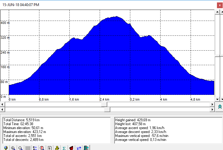
Hom (418 m)
- Tagline: Easy one hour walking to the top of Lastovo
- Starting point: hiking trail branch on the road Ubli - Lastovo, about 2,5 km from Ubli (see OpenTopoMap map)
- Trail type: Easy, signed trail (see altitude profile)
- Duration: 1 h (ascent only)
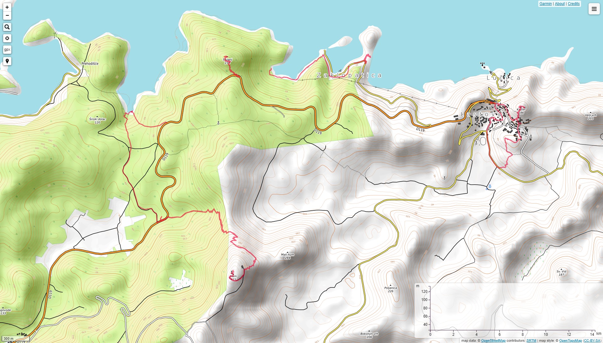
Sozanj (236 m)

- Tagline: An easy 15 min long trail to the peak with beautiful view (and with stamps of Croatian Hiking Trail HPO)
- Starting point: parking - view point on the road Ubli - Lastovo, about 3 km from Lastovo (see OpenTopoMap map)
- Tip staze: Easy, signed trail
- Duration: 15 min (ascent only)
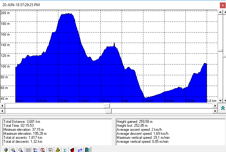
Lastovska šetnica and Lučica

- Tagline: 6 km long trail that visits almost all monuments of the Lastovo city. The photos and the tracks shows the 1st half of the trail. Lučica (1km by road) is accessible by bike.
- Starting point: Lastovo - Pjevor (see OpenTopoMap map)
- Trail type: Circled, eesy, signed trail (not signed with ordinary hiking signs), an asphalted road to Lučica (see altitude profile of half trail + Kašćel)
- Duration: 2 h (6 km) - circled, +0.8 km descent to Lučica
Zaklopatica, Ropa, Korita

- Tagline: Zaklopatica is a bay and place 2 km from Lastovo city. Korita is a bay, about 800 m far from Zaklopatica from the west, below Sozanj peak. Ropa is a natural pool at the east side of Zaklopatica. The approach to Ropa is short (5 min) but it requires some climbing.
- Starting point: Zaklopatica (see OpenTopoMap map)
- Trail type: Easy, signed trail to Korita, technically moderate but short to Ropa
Kručica Bay
- Tagline: Kručica is nice and silent bay accessible by foot (and by boat ) only. The shortest approach (20 min of hiking) is from East, from the road Ubli-Lastovo. This trail is drawn as unsigned at HGSS 's map issued 2010.
- Trail type: Easy, signed trail
Rača Cave

- Tagline: Rača Cave is interesting cave at the top of the hill on SE side of Lastovo island. The approach is via bad unpaved road from Lastovo or Skrivena Luka, a few km from Lastovo. The last 20 min is an easy hiking.
- Starting point: Lastovo or Skrivena Luka
- Trail type: Easy, signed trail
Photo-albums:
- Hom and Sozanj - by Dražen
- Lastovo Promenade and Lučica - by Dražen
- Zaklopatica (bay and place), Zaklopatička Ropa, Kručica (bay)
- Skrivena Luka, Lighthouse Struga and Rača Cave
Maps and GPS data:
- Lastovsko otočje, Tourist and tracking map, M 1:20.000, HGSS, Zagreb, 2010.
- OpenTopoMap Lastovo Map - on line (© CC-BY-SA OpenTopoMap)
- OpenTopoMap map of Lastovo with drawn wandering tracks (© CC-BY-SA OpenTopoMap)
- OpenTopoMap map of Lastovo with drawn bike tracks (© CC-BY-SA OpenTopoMap)
