Destinations:
- Telaščica, Strmci
- Oštravica, Orljak, Strašna Pećina
- Dragove, Mala Gospa Church, Lungo Mare
Tagline: A few hiking - walking trails around beautiful Dugi Otok
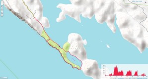
Telaščica, Slano jezero - Mir, Strmci
- Starting point: parking at the end of the road to Telaščica bay
- Trail type: Easy walking, the part from Slano Jezero along Strmci, somewhere, difficult pathless terrain (see altitude profile)
- Duration: 3 h (whole circle)
- Tagline: Nice walking around Slano Jezero - Mir (Salt Lake - Peace) with the try to walk along Strmci till fortress Grpašćak. From the eastern end of Slano Jezero, the trail is good, then connects with touristic path to Strmci and later disappears.
- Photo-album: Telaščica, Slano Jezero, Strmci by Dražen
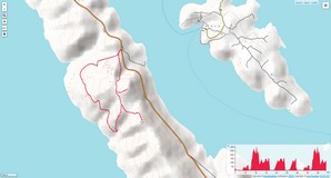
Oštravica - Orljak - Strašna Pećina
- Starting point: parking about 8 km from Luka to Brbinj
- Route: parkirng - Oštravica - Orljak - Strašna Pećina - parking
- Trail type: Signed trail on medium difficult karst terrain (see altitude profile)
- Duration: about 3 h (whole circle)
- Tagline: An easy ascent to not soo high peaks but with beautiful views (the highest has 301 m). The cave was visible from outside only (the visit must be announced).
- Photo-album: Oštravica - Orljak - Strašna pećina by Dražen
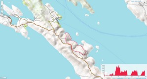
Dragove - Mala Gospa - Lungo mare - Dragove
- Starting point: point at the road Brbinj - Božava (near Dragove)
- Route: Dragove - Mala Gospa (Yang Lady) church - Lungo Mare - Dragove
- Trail type: signed but not well maintained trail from Dragove, trail along the sea (see altitude profile)
- Duration: about 3 h (whole circle)
- Trail type: Easy walking on signed but not well maintained trail from Dragove to Mala Gospa church. Afterwards , there is descending to the sea, a few nice bays and "lungo mare".
- Photo-album: Dragove - Mala Gospa - Lungo mare by Dražen
Maps:
- Dugi Otok, touristic - hiking map, M 1:20.000, HGSS, Zagreb, 2010.
- OpenTopoMap on-line map of Dugi Otok area (© CC-BY-SA OpenTopoMap)


