Destination: Drachenwand (1176 m / 3793 ft)
Starting point: St. Lorenz, parking lot close to the Restaurant Drachenwand at 486 m.
Ending point: like starting point
Duration: can vary a lot due to conditions and population (3 -5 h)
Altitude difference: entrance of the ferrata (Theklaquelle) at a hight of 670 m, 560 climbing meters (see altitude profile )
Difficulty: Climbing Level C, some D included
Tagline: Climbing adventure with changing wheather conditions and some adrenalin as well as great views above the Moon Lake.
Route: St. Lorenz - Parking Lot at Restaurant Drachenwand - Theklaquelle - Top Drachenwand - back to the parking lot
Mt Huts: possible overnight stay at Restaurant Drachenwand
Notes from the trip:
Climbing Drachenwand, August 12th, 2020
Starting in Regensburg too late we arrived after noon at the shores of the Moon lake; the lake were glancing in the summer heat. We went further to St. Lorenz and the parking lot close to the Restaurant Drachenwand at 486m.
As people are already coming back from climbing it gave us the chance of a nearly empty way up without pressure from the back. But it had not only advantages to be soo late…
Fully equipped we started, left the Theklaquelle behind us and added helmet and more at the Anseilplatz to stand after some meters at the entrance of the ferrata at a hight of 670 m, 560 climbing meters in front of us.
It didn’t take long to recognize: This ferrata is special, challenging and leads us to a respectful and careful approach. The only chance to go back is at the 60 meters marker ... after this you should really want to make it and believe in it yourself. I thought about going back, after 60 m, it was clear to me that this ferrata is more challenging than any I did before ... we both went on. I memorized the security number... The lake beneath you...
The ferrata has 20 named parts, starting with the Große Einstiegsleiter und Kleine Leiter. To the Wasserfall it still seems easy but after this the climbing starts to go up steeper to the Gamserl Garten for a first break and to remember: there is a shiny light blue lake below...
On the sunny side, hot iron in your hands (well, with gloves because of Corona rules). After this it goes on with some stone steps. Sounds easy but after this nothing works anymore without all muscles in tension and full concentration through Weiße Verschneidung und Graue Platte to the Franzosenschanze. Rest again with the view down...
Than you have two options, the one way with the hanging bridge is meant to be the easier one but ... It’s a special moment to stand in the middle of nothing high in the air but it isb actually more save than climbing. I challenged myself with trying to take pics of Drazen on the bridge, secured the backpack and me, for the phone it was a dangerous handling. Well, and that time I better didn’t look down...
The other side of the hanging bridge starts with an overhang … step by step to the left side. And than, if you look up a wall is waiting for you just straight up. And below you. And that was not all, after the first metres climbing this wall water drops came in slowly, shimmering silver grey in the sun. So beautiful. But oh my goodness. The most difficult part (C which is more like D) and a shower, which was growing more heavyly by the minute. “Go through, concentrate even more, but go, go.” I looked several times down where Drazen was climbing up. We were totally wet and the wall of course, too. One step I went too far, the carabiners too low to grasp, no chance for a step back. Breathe Maja, try again, slowly, one by one, I got them. And than up, pushing myself to the wall, keeping the stone very tight, securing the feet, pulling myself up the wet stone. My body remembered by itself how to climb. We made it! Wet and relieved and happy.
But I was exhausted and there were still the Quergang and the Last Gipfelwand to go. I realized 560 climbing metres can be very long. But as a present there is the look down again, this view over the whole lake, bit foggy now in aquarell colors. We made it higher than the devil, who didn´t fly high enough and ended up pushing a hole in the Drachenwand as the legend goes…
Going down I needed all my leftover energy and at the last part all concentration again. On the way down it is written that there were several accidents. Well secured and with newly equipped ladders there was at no time a risk to fall.
We made it back to the lake... and this time looking up to the wall in its best sundowner colors for a last pic. Great that we did it!
Photoalbum: Photoalbum by Dražen
Maps:
In order to show GPS tracks on the map click on the map icon:
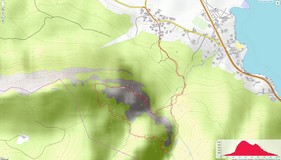
OpenTopoMap (© CC-BY-SA) area on-line map is here. 
Altitude profile of the trail is here
Approach: From Munich-Salzburg (A8 -A1) or Passau-Mondsee (A3-A1, 148, 147), than St. Lorenz - Restaurant Drachenwand parking lot
References:


