")
")


Destination: Klinac-grad Castle (341 m), Čuntić Tower (209 m)
Starting point: Tješnjak (139 m), Petrinjčica canyon, bridge on the road Hrastovica - Jabukovac, 2,5 km from Hrastovica
Ending point: Caffe bar "Zelena dolina" (148 m)
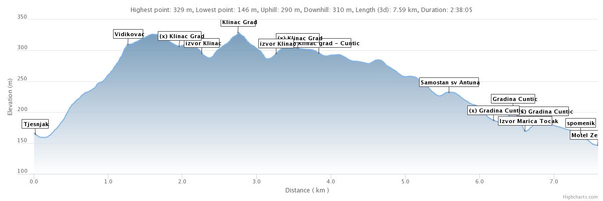
Length: 7,5 km / 2,5 h of walking
Difficulty: K1 (easy) Total ascents: 300 m
Tagline: In two and half hours of walking it is included the visit of two castles/towers (Klinac and Čuntić), local museum in St. Anthony Monastery in Hrvatski Čuntić. The end of the route is in caffe bar "Zelena Dolina". It is also possible to continue to visit Mountain hut Matija Filjak and to end at the starting point (additionally 2,5 hours of walking).

Route:
- Tješnjak - Klinac castle; 40 min
- Klinac Castle - Čuntić (village) - Čuntić castle - Caffe bar Zelena dolina, 1,5h
Route description:
- From the bridge at Tješnjak (where you can park your car), the signed trail leads along the coast of Petrinjčica (downstream) and after a two hundred meters it turns right and there starts ascent. The route crosses the oil pipeline before reaching the edge. Shortly, waling on edge, we are coming to "viewpoint". There is the end of the steep part of the trail. The views towards Petrinja and Hrastovička Gora are disturbed by vegetation, so for a more complete experience you should come in time of the year without vegetation.
- The trail continues straight through the light acacia forest, across the meadows, along the ridge (poor markings!), And at the first houses in the village Klinac there is a branch to Klinac grad - Klinac Tower (left).
- At the crossing, we turn left towards Klinac Castle. After 200 m, we turn right, downhill 200 m and then left. At that turn, a few meters from the road is a (neglected) spring (Izvor Klinac). We descend a little further and then climb to the Klinac-grad fortress. From the tower we return the same way to the houses and crossing where we turned for Klinac-grad.
- We continue about 300 m through the village, and turn right into the fields. Following the field path, after a 20-minute walk, a church and a Franciscan monastery dedicated to St. Antun Padovanski. There is also a small local museum in the monastery. A tour of the museum is possible in agreement with the friar.

- Od crkve, spuštamo se po cesti do cestovnog raskršća gdje se lijevo odvaja put za gradinu Čuntić.
- Skrećemo lijevo te kod izvora Marića točak, penjemo se 5 min uzbrdo do gradine.
- Od gradine Čuntić, vraćamo se do raskršća i cestom spuštamo do caffe-bara Zelena dolina.
- From the church, we descend along the road to the road junction where the road to the Čuntić tower separates to the left.
- We turn left and at the spring named Marića Točak, climb 5 minutes uphill to the tower.
- From the Čuntić tower, we return to the crossroads and take the road down to the Zelena Dolina coffee bar.
Map and GPS data:

- Tracks (gpx file) are here. In order to see them in OpenTopoMap application, please click on the map icon.
- In order to see interactive map of the area in OpenTopoMap application, please, click here.
- Za interaktivni visinski profil staze kliknite ovdje.
Linked trips: