")
")


Destination(s): Vrženica Canyon, Vela Luka Bay
Starting and ending point: Baška (auto-camp Bunculuka)
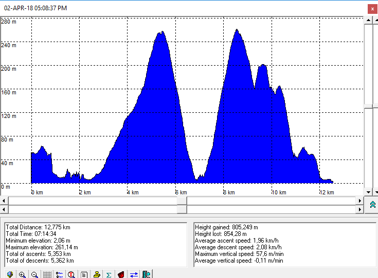
Altitude difference: 315 m (the altitude profile is here)
Trail type: Moderate, circled, signed trail
Duration: about 6 h of walking
Description: Nice, moderate trip that can be combined with bathing in springtime or in summer.

The route:
- Baška (auto-camp Bunculuka) - Vrženica bay - Vrženica Canyon - viewpoint Rebica - Vela Luka bay - Baška (camp Bunculuka)
Photo-albums:
- Baška - Vrženica bay - Vrženica canyon - viewpoint Rebica (by Dražen)
- Viewpoint Rebica - Vela Luka Bay - Baška (by Dražen)

Maps and GPS data:
- Krk, Turistic map 1:50000, Kartograf
-
The altitude profile is here
In order to view the GPS tracks from the trip, just click on the map icon:
Approach
- From the entrance of the Bunculuka auto-camp, the trails goes along the fence of the camp. When the camp is closed it could be possible to pass through the camp to Vrženica bay where is the entrance in the canyon.
Difficulty: hard terrain (stoned), some details in canyon require the usage of arms. No shadows on the way after entering canyon.
