")
")


Route: Visovac - Roški slap (Roški Waterfall)
Duration: 2 - 2.5 h (one way)
Difficulty: easy unsigned trail
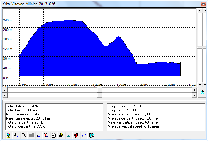
Altitude difference: 200 m (see elevation profile)
Attractiveness: ** from ***
Tagline: An easy walk through Krka National Park and the visit of the interesting part of its canyon.
Route description:
- The trail is not marked, but it is well built and the orientation is easy because it goes along the Krka river, upstream.
- The trail starts with the stairs close to forester's house (about 1 km from the dock for boats to Visovac island). The trail goes up providing beautiful views to Visovac island, Visovac Lake and to the gorge "Među Gredama".
- At the crossroads near the village, the road bends to the left and slightly down to the ruins of the fortress Kamičak, where according to the tradition was born the last Croatian king Petar Svačić. The gorge "Među Gredama" ("Between the cliffs") is very interesting but it is not easy to access and because of this it is bypassed by this route.
- Then, there the trail ascends and then descends to the deeply cut meadow. Circling around the meadow (or bypassing it), we arrive at the Roški Slap (Roški Waterfall), specifically to its part called Mlinice (Mills), where the restaurant is.
{gallery links=0 count=3 width=240 height=240}travels/dalmatia/krka_visovac-roski_2013-10-26/slides{/gallery}
Notes from the trip:
- Photo-album by Drazen
Approach:
- On the road Šibenik - Drniš at Pakovo Selo village turn towards Visovac (Drinovci and Ključ) and follow the signs to Visovac
- At the edge of the plateau where the road goes down to the dock for boats to Visovac there is a belvedere and the monument to King Peter Svačić
- From the dock (for boats to Visovac), where you can park, continue along the Krka, upstream by the forest road for about a kilometre. At the end of the road there is a forester's house. Shortly before the hut, to the right, there are stairs where the trail begins.
- Roški Waterfall is accessible by road (car)
Maps and GPS data:
- Topographic map of Sibenik TK25 -2-4 (520-2-2), 1:25000, DGU, Zagreb
- Topographic map of Sibenik TK25 -2-4 (520-2-4), 1:25000, DGU, Zagreb
- The tracks (KML file) are here, and to display them in Google Maps application, click on the map icon
- Elevation profile tracks is here
Points of interest nearby
- National Park Krka
- Čikola Canyon
- King Petar Svačić monument at the belvedere to the island Visovac
Notes:
- The route is placed inside the National Park "Krka"
- There is a restaurant at Roški Waterfall. There is no drinkable water along the route
References