")
")


Destination: Bijele Stijene - Summit (1334 m) - Vihor Trail
Beginning: Parking at the branch of the road Mrkopalj-Jasenak
End: the crossing "13th km" on the road Mrkopalj-Jasenak
Duration: about 6 h
The level of difficulties: Moderate to high
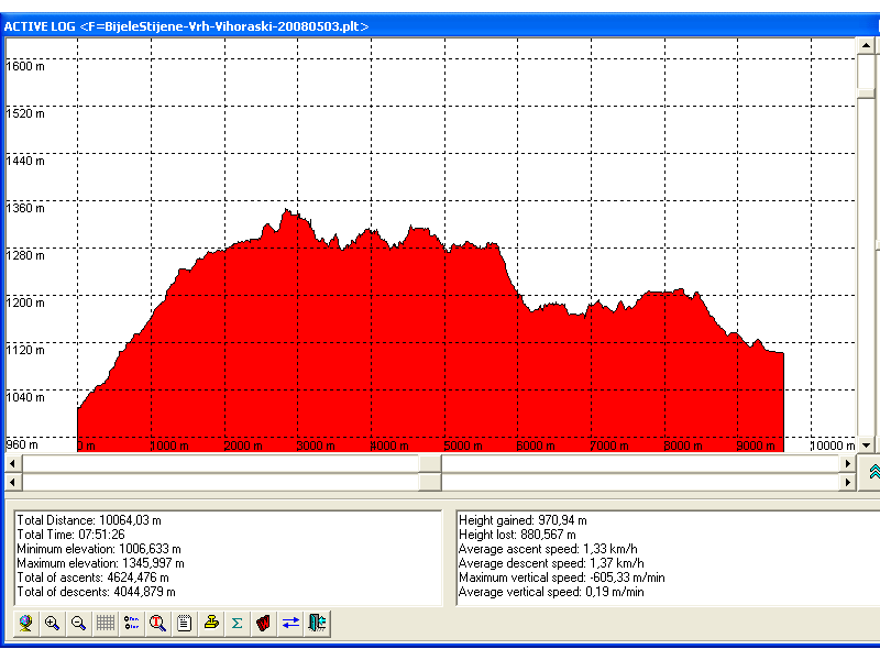
Altitude difference: 325 m Altitude profile is here
Attractivity: *** (of ***)
Convenient season for visit: Summer
Introduction:
- Bijele stijene (White Rocks) is a 4 km - long chain of rocks of unique beauty, cut with wood and little green dales. Very suitable place for a runaway from noise, pollution and other side-effects of civilisation and summer heat.
- Bijele Stijene and Samarske Sijene (Saddle Rocks) are protected as a strict nature reserve. The Vihor's trail is one of the most beautiful hiking trails in Croatia. There is no more to say.. it is worth seeing.
- The proposed route leads from the parking to the mountain hut, than to the summit and after that via The Vihor trail to Samarske stijene. The rest is 20 min long descent to the road, only.
- There is the mountain hut and the shelter in Bijele Stijene. The hut is very close to the summit and it is the starting point for:
- ascent to the summit of Bijele Stijene (1334 m): 15-25 min
- ascent to Velika Javornica (1374 m): 1,5 h
- Samarske stijene (by Vihor's Trail): 4 h
- At Samarske Stijene there is a shelter. That can be the starting point for other trips through Samarske stijene
- Traditional approach for accessing Bijele Stijene leads from Jasenak village (24 km from Ogulin). The position of Ogulin you can find here, and more information about Ogulin here. Jasenak is connected with Ogulin by local road Ogulin-Jezerane. It is needed to follow signs for HOC Bjeloasica. Ogulin is only one hour of driving distanced from Zagreb (highway A1, exit Ogulin).
Starting point:
- Parking place (1009 m) at the end of the branch to Bijele stijene on the road Mrkopalj-Jasenak (Begova staza). The barnch is 7 km far from Jasenak and 1,7 km long. This place is the point the closest to Bijele Stijene and reachable by car or by small buses. And this parking is on the hiking trail from Jasenak (the closest village accessible by public transport).
Ending point:
- "13th km" (1100 m) on the road Jasenak-Mrkopalj. This is about 6 km far from the starting point, 13 km far from Mrkopalj and about at the same distance to Jasenak.
- Alternatives:
- after Ljuska, to descent to the road via Ačkova dolina (Ačkova valley) and through Klanac Kostura (Skeleton Gorge) to the forester road which leads toward the starting point
- about 5 h of walking
- from the pass Boce, to descent to the end of Klanac Kostura. This is shorter variant but less attractive (it avoids Ljuska, the most interesting part of Vihor Trail)
- about 4 h of walking
- return using the same way after ascent to the summit
The level of difficulties: Moderate to high
- Up to the mountain hut is short but steep and without any other difficulties.
- From the hut to the summit (it depends on the chosen variant) a little climbing is needed. Somewhere the trail is secured by cable. This path was convenient for my 2,5-year-old daughter (with my help).
- The Vihor's trail is demanding but very interesting. There is no climbing (just a little in Ljuska) nor big ascents nor descents, but the trail leads from a stone to another stone and this can be difficult for some people (but funny for others).
Duration: about 6 h
- parking - the hut: 40 min
- the Hut - the Summit of Bijele Stijene - the Hut: 40 min
- Vihor's trail: 4 h
- Ratko's shelter - 13th km (road Mrkopalj-Jasenak): 20 min


The route description:
- From the parking place through the forest ascent about 40 min following signs. Close to the parking there is a small shelter convenient for a few mountaineers. 10 min before the hut there is a branch to Velika Javornica. The trail is completely in the shadow and there are no problems with summer heats.
- The summit can be reached through a few variants in duration of 15-25 min (in one direction). My recommendation is to go to the summit following the signs for the summit and Samarske Stijene and after 100 m to deviate on the left and a little down. There is a narrow gap between rocks (convenient for slim people). After that it is needed to deviate on the right to the summit. The descent is possible on the other side (it is secured with cable) to the crossing Vihoraški put (Samarske stijene) and return to the hut.
- From the hut it is needed to go back to the crossing and with Vihoraški trail to Ratkovo shelter in Samarske stijene
Maps and GPS tracks:
- GPS tracks (Ozi Explorer, PLT format) are here (see Notes on GPS data)
- Jasenak (Google Maps) and GPS tracks in KML format (Google Earth)
- Bijele i Samarske stijene, Map No 11a, SMAND d.o.o., Varaždin, 2002.
- Bjelolasica, Map No 11b, M 1:25.000, SMAND d.o.o., Varaždin, 1995.
Approach and Accommodation:
- The description of the approach to Bijele Stijene and Samarske Stijene with accommodation information is here


Equipment:
- rucksack, hobnailed shoes, water, food
- Sleeping bag and bedding in the case of the sleeping planned in a mountain hut or in a shelter. In the shelters there are no mattresses.
Other interesting things:
- Begovo Razdolje - the highest village in Croatia (1078 m)
- Matić Poljana - monument to frozen 26 partisans in 2nd world war
- "Frižider" (The Refrigerator), Bijele stijene - about 50 from the hut there is easy accessible karst sinkhole with everlasting snow
- Kamačnik Canyon
Related trips:
- Zub (the Tooth), Samarske Stijene
- The Kamačnik Canyon - very interesting 3,2 km long canyon near Vrbovsko,
Control points of Mountaineering trails:
- Hrvatska planinarska obilaznica
- Hrvatske planinarske kuće
- Kapelski planinarski put
- Goranski planinarski put
Notes:
- Along the trail there is no drinkable water, but there are no problems with summer heats!
- Up to the late springtime (May) Vihor's trail is less passable because of the old snow layers (up to a few meters).
- The Mountain Hut Bijele Stijene is partially supplied (with beverages, no food) when is opened, but without drinking water! There is a cistern. Ratko's shelter has a cistern, but the water is not drinkable (without disinfection).
- The area of Bijele stijene is poor with signal for mobile phones. It is recommended to use other communication equipment - radio-stations.
References:
- Bijele and Samarske Stijene (by Dinaric-ZG on SummitPost.org)
- Other mountaineering references are here