")
")


Route: Mt. Lodge Zavižan - Ciganište - Mt Hut Alan - Premužić Mountain Trail - Mt. Lodge Zavižan
Starting and destination point: Mt. Lodge Zavižan (1594 m)
Duration: two days ( 9 + 7 hours of walking)
Difficulty: Medium difficult marked trail (see the notes and altitude profile)
Tagline: The HPD Zrin Summer Camp 2015 main trip. Very nice trip despite of the giving up of a few hikers including the guide, extreme hotness for this region and a demanding trail. Probably the best moment of the trip was the welcome in the form of the cold beer, brought by our colleagues at the end of the route, after 12 hours of walking
Travel Notes:
- As Ante from Zavižan said.. "What are we guilty for of walking this trail " (The North Velebit Seaside Terrace trail) at his hotness? Regardless of these words it was nice but difficult, Last time, it was only two degrees Celsius, winding and rainy (despite of the 1st day of the summer) and I wanted to experience this trail under better conditions. The rest of the team was 1st time there.
- The official travel notes (written by Vlasta) are at the HPD Zrin Hiking Club page
July 23, 2015
Mt. Lodge Zavižan - Ciganište - Seaside Terrace Trail - Mt Hut Alan, about 9 h of walking (we spent 12!)
Photo-album from Seaside Terrace Trail by Dražen
Jully 24, 2015
Mt Hut Alan - Premužić Mountain trail - Mt Lodge Zavižan, about 7 h of walking
Photo-album from the Premužić Mountain Trail by Dražen
The members of the group:
Vesna, Vlasta, Maja, Šuco, Slavek, Vlado, Zlatko and Dražen (8 souls)
Maps and GPS data:
- National Park Sjeverni Velebit, Map No 16a, M 1:30.000, SMAND d.o.o., Varaždin, 2005.
- Sjeverni Velebit, Map No 16, M 1:30 000, SMAND d.o.o., Varaždin 1995.
- Topographics map TK25 Rab-2-4 (418-2-4), M 1:25000, Državna geodetska uprava, Zagreb
- GPS tracks (KML file) are here
- In order to view these GPS tracks, click on the icon of the map:

Notes:
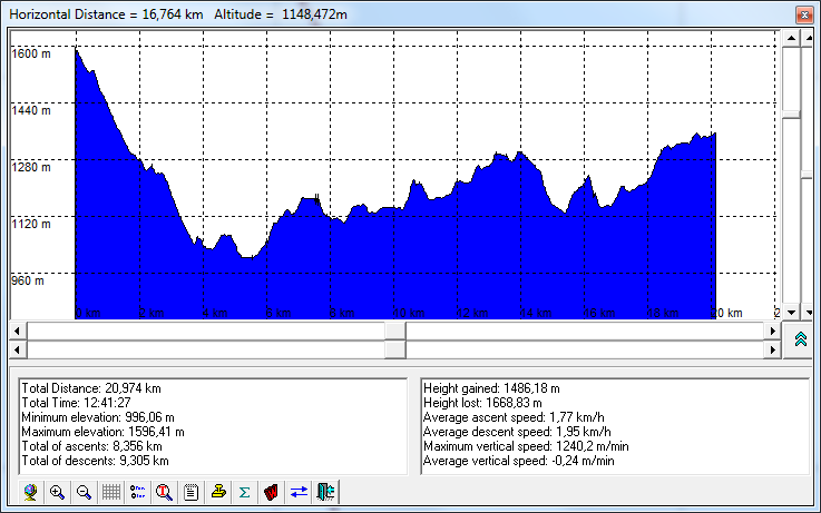
- The difficulty of the trail is defined by its length (about 20 km), karst terrain and huge altitude difference (a lot of ascents and descends - see the altitude profile) and the missing of any shelter and drinking water along the route.
- The trail is well signed.