")
")


Destination: SE Velebit - Crnopac - The Little Prince Trail
Start & end: Parkplace Šimlašica, near Prezid pass (about 1000 m)
Length: 5 h / 7,3 km; Uphill: 600 m; Elevation range: 987 - 1171 m
Difficulty: Fit: 🥾🥾⚪⚪; Technical: very difficult (see Difficulties)
Tagline:
- "At this trail the time actually ceases to exist, because you are totally amazed by the beauty of the landscape so that you forget everything else." says Slavko Tomerlin - Tatek, the explorer of that part of Mt Velebit and the author of the trails.
- Although it requires a climber's skills, the selected route - the Little Prince Trail is certainly more interesting than difficult.
- It is beautiful but a difficult circled trail, easy accessible (just 40 min of walking far from parking place). It is convenient for refreshment during summer vacations in North Dalmatia.
Route:
- Parking/crossing at Šimlašica -> Mt Shelter Crnopac: 40 min
- Mt Shelter Crnopac -> Put Malog princa (Konoba -> Dvori -> Niska vrata -> viewpoint -> Zdenko' s hole -> Šušnjevac -> Slipi klanac (Blind Gorge)-> Tisni klanac -> Papratnjak -> Krivi klanac -> Stankina vrata -> Kičma -> Nebeska vrata -> Bili kuk) -> Parking/crossing at Šimlašica
- Options:
- Kita Gaćešina peak: +2,5 h
- Orlov Kamen: +30 min

Route description:

-
Velebit at SummitPost created a very good description of Crnopac (including the Little Prince Trail) with nice photos
-
The northern route requires only 40 minutes of walking from a convenient parking place to The Crnopac Mountain Shelter
-
The signed ascending trail passes a few times the forest road and after 40 minutes of walking you arrive to the shelter. There are two branches: the branch to Kita Gaćešina (after 20 minutes) and trail to the Little Prince Trail and Bili Kuk just before the shelter.
-
From the shelter, you need to return 50 m and turn on the right, descending to the crossing Bili kuk - Put Malog princa (the Little Prince Trail)
-
In order to visit Kita Gaćešina, the peak beside the Little Prince Trail, it is recommended to visit Little Prince Trail first, then Bili Kuk and after that, you can either go to the shelter (30 min) or to get back 15 min to the end of the Little Prince Trail and the branch to the Kita Gaćešina.
-
The trail leads from one to another breathtaking karst form through gates, canyons and ridges. We recommend you to visit all signed (and not signed) structures.
-
Little Prince trail is very well signed. The only doubt is whether to visit Konoba (Tavern) or Dvorska Vrata (Castle Gate). Konoba is a short dead end extension and the trail goes through the gate.
-
The circle of the trail has 600 m in diameter only but it requires 3-4 hours of walking. It depends on the number of breaks, visiting extensions, taking photographs...
Approach:

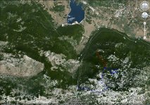
- For basic approach see GoogleMaps Interactive map of Crnopac. From the continental side, the main approach is from the town Gračac, and from the coastal side town Obrovac or Zadar. Gračac is accessible from Zagreb by highway A1 (220 km from Zagreb, exit 14 - Gračac, Lovinac, Sv. Rok) and then by state road D27.
- From the road Gračac - Prezid (- Obrovac), 6 km from Gračac, there is a bad forest road (but passable for personal cars), on the left, backward, about 1200 m before the tunnel (Prezid pass). There is a very sharp turn to the unpaved branch on the left. After about 4 km of this forest road there is the crossing and widening convenient for parking.
- If you miss this branch you can proceed 200 m up to a widening of the road or to the next one (where another route to Crnopac starts) and to return.
Difficulties:
- This is the trail with the most secure facilities (cables, scales, bolts...) that I have visited in Croatia. But it is safe and passable without special difficulties for experienced people.
- In my opinion the most interesting forms are: Zdenkova jama (Zdenko's hole), Kičma (Back-bone) and Bili kuk (White Cliff)
Recommended equipment (summer):
- An appropriate rucksack, mountaineering boots, water, food and other equipment needed for whole day long walking on karstic terrain
Accommodation:

- Mountain shelter Crnopac
The most appropriate seasons for visiting:
- Summer. In springtime or fall there is a possibility for snow and walking on such karstic terrain can be dangerous.
Maps and GPS data:

- Crnopac, Turističko-planinarski zemljovid, 1:25.000, HGSS, 2017
- Južni Velebit III (Southern Velebit III), Map No 18b, M 1:30 000, SMAND, Varaždin 2007.
- Topographic map TK25 (1:25000), Gračac 2-3 (470-2-3), Državna geodetska uprava, Zagreb
 Click on map icon or route view in GoogleMaps.
Other interesting places::
- Cerovačke caves - the bigest caves complex in Croatia
- Krupa Canyon
- Zrmanja Canyon
- more than hundred holes and caves at Crnopac
Notes:
- Little Prince Trail belongs to the group of most difficult trails in Croatia (it can be compared with Vihoraski trail), but it is not too long (3-4 hours of walking/climbing)
- The trail is placed in Velebit - Natural Park. Visiting rules must be strictly followed.
- There are no drinkable water along the route! Mountain shelter Crnopac has a cistern.
- Crnopac by Velebit @ SummitPost
- Crnopac at Mountaineering forum (HR)
- Slavko Tomerlin - Tatek, Mreža planinarskih puteva na Crnopcu (The network of mountaineering trails at Crnopac), Hrvatski planinar No. 4/2004
- The list of other mountaineering references is here.
- It is not strictly mountaineering literature but it is noteworthy Little Prince written by Antoine de Saint-Exupéry)


