")
")


Destination: Kiza (1274 m), Žuti Kuk (1180 m), Vranji Kuk (1131 m)
Beginning: Village Stupačinovo (950 m) or The Mountain Hut Prpa
End: The same as the beginning
Duration: 6.5 hours of walking
Difficulty: Medium difficult signed trail.
Altitude difference: 349 m
Attractiveness: *** to *** (max ***)
Convenient seasons for hiking: springtime, summer, autumn
Tagline
- Three beautiful cliffs, with a very interesting trail between them
Maps:
- Dabarski Kukovi, Srednji Velebit (Central Velebit), Map No 17a, SMAND d.o.o., Varaždin, Croatia, 2003
- Srednji Velebit (Central Velebit), Map No 17, M 1:30 000, SMAND d.o.o, Varaždin, Croatia, 1996

Introduction
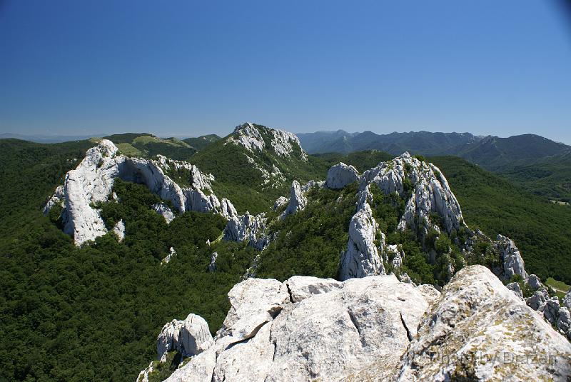
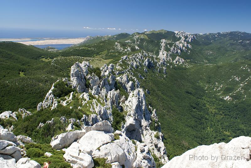
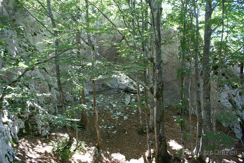
- Dabarski kukovi (Dabar cliffs) is the collection of interesting rocky summits in Central Velebit, Croatia. They are easily accessible from the village Baške Oštarije (or simply Oštarije) on the road Gospić-Karlobag (about 3 hours of driving from Zagreb). In Oštarije there are a few accommodation facilities (a hotel, a few mountaineering huts) .
- Hiking and climbing in combination with bathing in the sea and comfortable accommodation (for mountaineering expectations) very close to the seaside, but on the 900 m altitude where it is always fresh, offer the visitors a special experience.
- It is hard to say something shorter and more informative about Kiza and Žuti Kuk cliffs than words of our friend Vanja:
"Kiza is one of the most famous and beautiful summits of Mt Velebit and probably the most accessible one. There is only one hour of walking from the closest road and the trail does not have any difficulties.
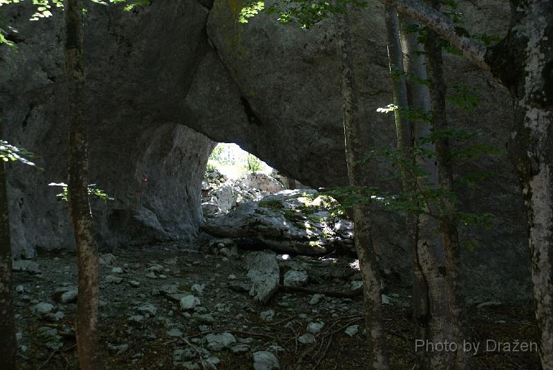
Žuti Kuk (The Yellow Cliff), Kiza's neighbour is my favourite Croatian summit, because there are plenty of interesting places on the ascent - views toward other summits, toward the sea and islands and a lot of rocks convenient for climbing, a natural stone bridge, a stone gate, an abyss near the trail... and all of these phenomena are easily accessible"
Žuti Kuk (The Yellow Cliff), Kiza's neighbour is my favourite Croatian summit, because there are plenty of interesting places on the ascent - views toward other summits, toward the sea and islands and a lot of rocks convenient for climbing, a natural stone bridge, a stone gate, an abyss near the trail... and all of these phenomena are easily accessible"
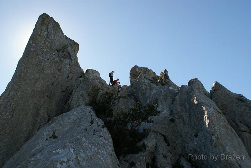
- And the third cliff - Vranji Kuk will surely attract people who have enough strength and will to climb it.
- Dabarski Kukovi belongs to Nature Park Velebit
- The route leads from Stupačinovo village (4 km from Oštarije) to the cliff Kiza, then to Žuti Kuk and after it to Vranji Kuk. From the last one it returns to Stupačinovo. There are possibilities for shorter and longer alternative routes.
- The starting point is only 20 km far from the sea (the town Karlobag) and a refreshing shower after the trip can be replaced with bathing in the sea (and showering on the beach).
The route:
- Mountain hut "Prpa" - Stupačinovo village: 4 km by car or 30 min by foot
- Stupačinovo - Kiza (1274 m): 1 h 15 min
- Kiza - Žuti Kuk (1180 m) : 2h
- Žuti kuk - Vranji kuk (1121 m) - 1,5 h
- Returning via The Premužić Trail to the starting point: 1h 45 min
- Total: about 6,5 hours of walking (from and to Stupačinovo)
- Alternatives:
- From Vranji Kuk continue to Ravni Dabar via Škrbina instead of returning to Stupačinovo. In that case it is needed to organize a car from Ravni Dabar to Prpa (2 hours of walking more + 10 km by car)
- Ravni Dabar is a mountain hut close to the Velebit transversal road
- Ravni Dabar is a mountain hut close to the Velebit transversal road
- To get back after Kiza(2 hours of walking)
- To get back after Žuti kuk (4 hours of walking)
- To combine ascent to Kiza with ascent to "Kuk od Pečica" and/or ascent to Grabar cliff (this will be described separately)
- From Vranji Kuk continue to Ravni Dabar via Škrbina instead of returning to Stupačinovo. In that case it is needed to organize a car from Ravni Dabar to Prpa (2 hours of walking more + 10 km by car)


GPS data:
- My map with the drawn route is here
- GoogleEarth "klm" file is here,and GoogleMaps view with the shown route is here
- Tracks, plt format (OziExplorer):
Approach:
- See the page: Baške Oštarije - Approach and accommodation (by Dražen)
- From the road to Stupačinovo there is a 3-km-long paved branch that starts at the end of the village toward the sea, after the hotel Velebno.
- The mountaineering hut Prpa is accessible from the road Gospić-Karlobag via a branch that starts immediately before the Oštarije pass (from the continental side).
The route description:
- Stupačinovo can be accessed from Prpa by car (about 4 km) or directly on foot (about 30 min)
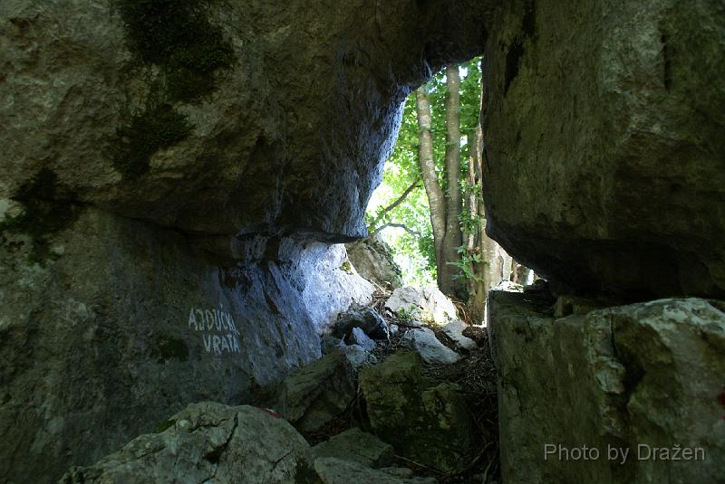
- There are two trails from Stupačinovo to Kiza. The southern one is shorter but more difficult than the western one. Because its orientation this way is hot (there is no forest), but there are interesting views toward the sea. The beginning of this trail is not well signed and I cannot recommend this variant. The other one (from the east) leads beside the miniature lake ("Kamenica") through the forest. This variant leads to Grabar and to Kuk od pećica, too. There is another variant of the eastern way through Ajdučka vrata (signed by Vlado Prpić). It starts on the road, about 50 meters after "Kamenica". After joining both variants we reach the branch to the cliff "Grabar" and further the branch to the cliff "Kuk od pećica". Without deviating to the branches and following the signs we reach Kiza.
- There are two trails to the rock of Kiza, too (from the control point with stamps). The direct one is more difficult (and dangerous when the rocks are wet) and the other is easier (it starts a few meters to the west). The ascent to the Kiza rock requires a little climbing, but is convenient even for school aged children and inexperienced hikers.
- In order to reach Žuti Kuk you can choose between two trails, again :-). The direct way is signed by Vlado Prpić and it is difficult. The other one is traditional and is quite interesting (see intro). It starts from the south variant of the route to Kiza (from Stupačinovo). It is needed to get back a few hundred meters and after that to deviate on the right before descending toward Stupačinovo. Beside the trail there are an amphitheatre, a stoned bridge and an abyss and other karst phenomena.
- The trail between Žuti Kuk and Vranji kuk is moderately difficult but interesting. One descent on the route is secured by cable. On the route there is a brench that leads to a belvedere. After climbing the belvedere it is needed to return a little to the trail and to bypass the rocks.
- There is a moderately difficult ascent only ten minutes of walking to the Vranji Kuk from the crossing with the pale signs. This ascent is absolutely worth seeing and climbing.
Equipment needed:
- rucksack, hobnailed shoes, water, food, sleeping bag...


Other interesting things:
- The belvedere Kubus on the Oštarije pass
- Basača (1089 m) - a beautiful summit above "Prpa" (only 20 min of walking) with a stunning view toward the sea and islands
- The Botanical Garden (on the branch to Prpa from the road Gospić-Karlobag)
- The Educational Trail Terezijana (the branch of the road Oštarije-Karlobag)
Accommodation:
- See the page: Baške Oštarije - Approach and accommodation (by Dražen)
References:
- Velebit, photo gallery Dabarski kukovi @ SummitPost
- The list of other mountaineering references is here
NOTES
- The route is placed in the karst area without drinking water (except the spring in Stupačinovo). There are no shelters and there are no food supplies (except a small shop in Oštarije). In the hut there are refrigerators and showers (with additional cost).
- For the route planners, it could be better to start with Vranji kuk or even from Ravni Dabar. We lost signs on the descent from Vranji kuk (signed trail, drawn on Map No 17a from SMAND is a little to the West) but in that area the orientation is not difficult.
- Our timing for group of about 20 persons with kids and not well prepared for long walking: Prpa (9:45), Stupačinovo-trail beginning to Kiza (10:50), Kiza (12:30), Žuti kuk (15:30), Vranji kuk (17:45), Prpa (19:15) - Total: 9h 30 min
- The world famous phenomenon of Mt Velebit is strong NE wind called Bora (Bura - Croatian).
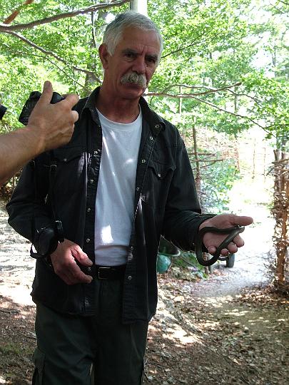
- With a minimum attention there is no real danger but it is necessary to warn visitors about the biggest and poisonous European snake - horned viper (pepeljasti poskok - HR, Vipera Ammodytes - lat). The owner of the mountain hut Prpa, Vlado Prpić hunts them and examines them and he can give a lot of information about them.


